


No products in the cart.
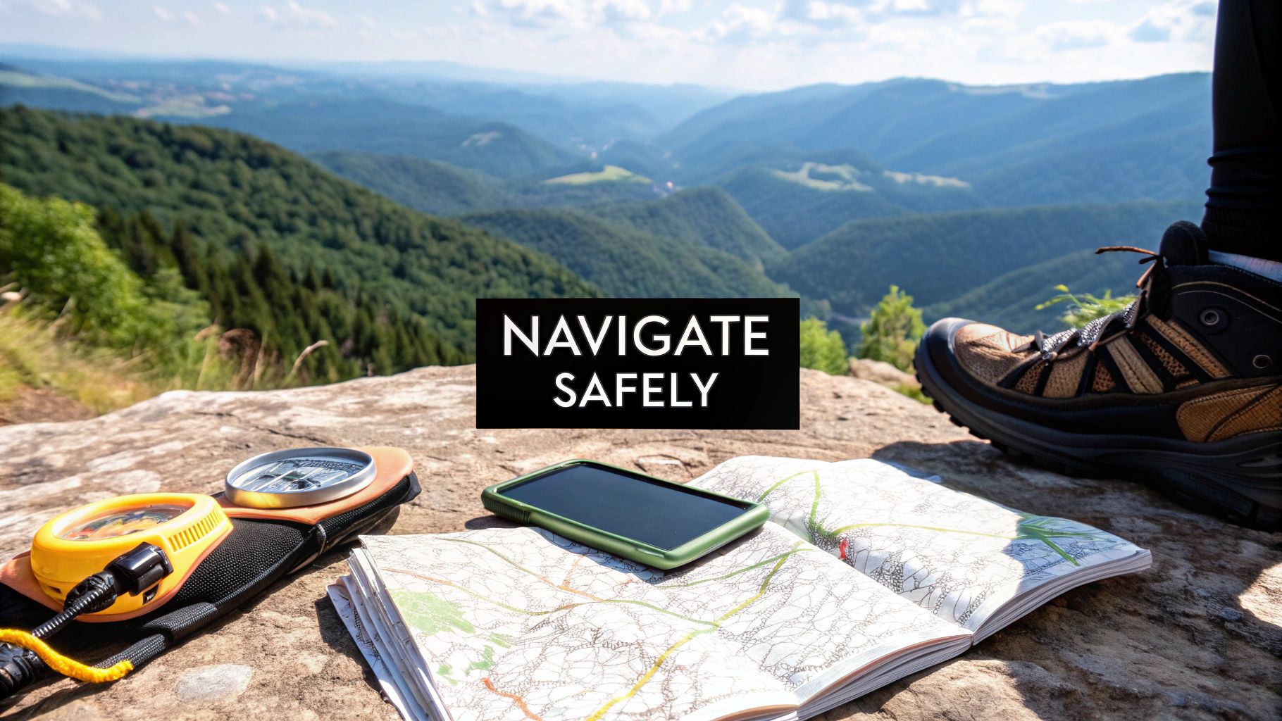
Don't let the fear of getting lost keep you off the trail. This guide is here to demystify hiking navigation, walking you through the four essential types of tools that will have you exploring with total confidence. We'll cover everything from the old-school reliability of a map and compass to modern GPS units and the powerful apps on your phone.
Building Your Hiking Navigation System

Getting your navigation gear sorted isn't about finding one magic device. It’s about building a smart, reliable system. Think of it like a toolkit for the trail—you need different tools for different jobs, and more importantly, you need backups.
The whole point is to layer your tools so that if one fails—a dead battery, a cracked screen, no satellite signal—you’re not left guessing. You just pull out the next tool and keep moving. This guide will show you how to build that kind of dependable system, piece by piece.
The Four Pillars of Modern Navigation
Let's break down the four main categories of navigation aids. Each one shines in different situations, and knowing their strengths is the first step to creating a setup that fits how you hike.
Here's a quick look at the core tools we'll explore:
- Map and Compass: The classic duo. It's the battery-free, fail-proof foundation of real navigation skill.
- Dedicated GPS Devices: These are the tough, purpose-built gadgets with fantastic satellite reception and durability, made for the serious stuff.
- GPS Watches: Super convenient for at-a-glance directions and fitness tracking, they're a favorite for trail runners and anyone moving fast.
- Smartphone Apps: Incredibly powerful and accessible, these apps turn your phone into a feature-rich navigation tool with offline maps and trail beta.
Before we dive deep into each one, this table gives you a quick side-by-side comparison. It’s a great way to see where each tool fits in.
Comparing Navigation Tools at a Glance
| Tool Type | Best For | Key Advantage | Main Limitation |
|---|---|---|---|
| Map & Compass | The ultimate backup; learning fundamental skills. | 100% reliable—no batteries or signal needed. | Requires skill and practice to use effectively. |
| GPS Device | Remote, multi-day trips in challenging terrain. | Extreme durability and superior satellite reception. | Can be expensive and has a learning curve. |
| GPS Watch | Trail running and fast-and-light day hikes. | Unbeatable convenience and quick-glance info. | Small screen size and limited battery life. |
| Smartphone App | Day hikes and well-traveled trails. | Easy to use with a large, familiar interface. | Fragile and highly dependent on battery life. |
Having this overview in mind helps frame the role of each tool. Now, let’s get into the specifics.
By combining these tools, you transform navigation from a source of anxiety into an empowering skill. A well-rounded system means you’re prepared for anything the wilderness throws your way, from a sudden storm to an unexpected detour.
This guide will help you figure out exactly which tools make sense for your adventures, making sure you always find your way. Let’s dive in.
Mastering the Classic Map and Compass
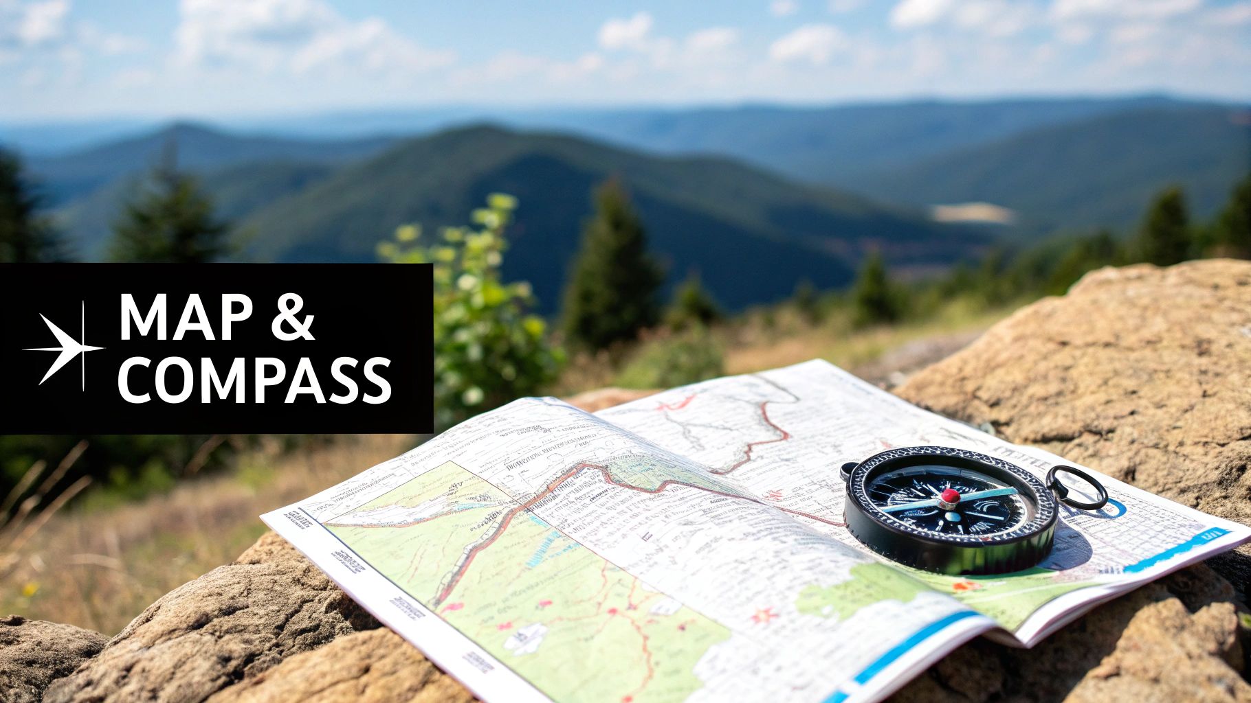
Long before screens lit up our trails, navigation was all about paper and a magnetized needle. Learning to use a map and compass is like learning the grammar of the outdoors—it’s a timeless skill that gives you a deep, reliable understanding of your place in the world. Even the most advanced navigation tools for hiking are built on the principles this classic duo established.
Think of this pair as your ultimate safety net. A map and compass never run out of batteries, never lose signal, and are tough as nails. Mastering them not only builds rock-solid confidence but also forges a genuine connection with the landscape, turning you from a passive trail-follower into a true navigator.
Decoding the Language of the Land
A good topographic map is so much more than a simple drawing. It’s a detailed story of the terrain, and the language it uses is contour lines. The best way to think about these wavy brown lines is as slices of a mountain, each one representing a specific elevation.
When the lines are crammed together, you’re looking at a steep climb—think of them as rungs on a ladder. When they’re spread far apart, the terrain is gentle and flat.
- Reading Elevation: You'll see thicker lines called index contours, which have the actual elevation printed on them (e.g., 8,200 ft).
- Identifying Landforms: V-shaped contours that point uphill show a valley or gully, while U-shaped contours pointing downhill trace a ridge.
- Visualizing the Trail: Following these lines with your finger lets you "see" the climbs, descents, and flat stretches of your hike before you even take a single step.
A topographic map gives you a bird's-eye view with X-ray vision. It shows you not just where the trail is, but what the land itself is doing—revealing the hidden shape of hills, valleys, and ridges that a simple line on a screen can't convey.
Finding Your Way with a Compass
Your compass is the map's indispensable partner. Its main jobs are to align your map with the real world around you and to help you walk in a straight line toward a specific point. This is called taking a bearing, and a quality baseplate compass is a non-negotiable piece of gear for any serious hiker.
Using a compass isn't some kind of black magic. It's really just a straightforward process of lining up three things: the direction you want to go, the north on your map, and magnetic north.
Taking a Bearing from the Map
Here’s a quick rundown of how to point yourself in the right direction:
- Align the Compass: Lay your compass on the map so its long edge creates a line from your current spot to your destination. Make sure the direction-of-travel arrow is pointing toward where you want to go.
- Turn the Dial: Now, rotate the compass dial (the bezel) until the orienting lines inside it are perfectly parallel with the map's north-south grid lines. The orienting arrow should be pointing to north on the map.
- Find Your Direction: Lift the compass off the map and hold it flat in front of you. Turn your whole body—not just your hands—until the red magnetic needle is nestled perfectly inside the outline of the orienting arrow. Your direction-of-travel arrow is now pointing exactly toward your destination.
This is the cornerstone of off-trail navigation and your most trustworthy tool when a fog rolls in or landmarks disappear. For a deeper dive, you can learn more about how to use a map and compass in our complete guide. It’s a fundamental skill that ensures you’re prepared for anything, making it one of the most vital navigation tools for hiking you can master.
Why Dedicated GPS Devices Still Reign Supreme
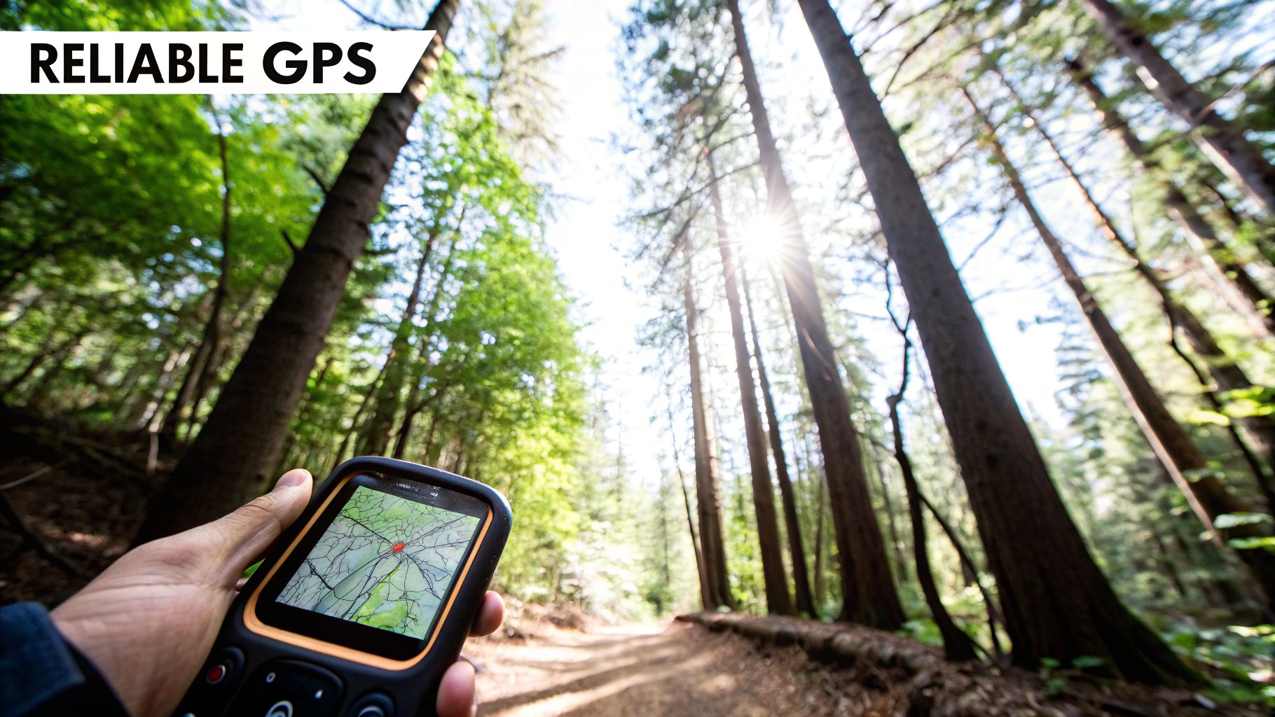
Sure, the smartphone in your pocket has a GPS app. And for a lot of well-marked trails, that’s probably enough. But when you start venturing further out—deep into canyons, under thick forest canopies, or anywhere cell service is a distant memory—a dedicated GPS device becomes your most reliable friend.
Think of it like this: your phone is a Swiss Army knife, and a handheld GPS is a purpose-built survival knife. The Swiss Army knife is handy, but when things get serious, you want the tool designed for one job and one job only. These rugged units are engineered to find your location accurately and reliably when everything else has failed.
That focused design is exactly what makes them one of the most essential navigation tools for hiking in challenging terrain. They're built to be dropped, soaked, and used with frozen, gloved fingers—a level of grit no smartphone can honestly claim.
Unbeatable Satellite Reception and Accuracy
The real magic of a dedicated GPS lies in its powerful antenna and sophisticated satellite receiver. Your phone is busy juggling Wi-Fi, cell signals, and Bluetooth, but a hiking GPS is obsessed with one thing: locking onto multiple satellite networks like GPS, GLONASS, and Galileo.
This multi-network capability means the device can see and talk to more satellites at once. The result? A faster, stronger, and more precise location fix, especially in those tricky spots where a phone would give up.
- Deep Canyons: Where steep rock walls block out most of the sky.
- Thick Forests: Under a dense canopy that scrambles weaker signals.
- Extreme Latitudes: In remote northern or southern areas where satellites are spread thin across the horizon.
If you're curious about the science behind it all, this guide is a great place to start for understanding how GPS works. It really highlights why specialized hardware makes such a difference in tough conditions.
Built for the Backcountry
Beyond just finding satellites, these devices are built from the ground up for the realities of the trail. The features aren't gimmicks; they are practical solutions to the real-world problems hikers face.
A dedicated GPS device is your lifeline in the backcountry. It’s not just a tool for convenience; it’s a piece of safety equipment designed to function flawlessly when you need it most, providing peace of mind that a fragile, battery-hungry phone cannot offer.
This is why the global market for hiking GPS trackers keeps growing. It’s expected to be worth around $500 million USD in 2025 and is on track to hit nearly $1.5 billion USD by 2033. That’s a powerful testament to how valuable these tools are for the millions of people heading outdoors.
Essential Features for Serious Hikers
Today’s handheld GPS units are more than just a moving dot on a screen. They’re complete navigation systems for planning, executing, and safely returning from your trek.
- Exceptional Battery Life: We're talking 100+ hours of tracking on some models. Better yet, most run on replaceable AA batteries. Just pack a few spares, and you have virtually unlimited power for a week-long trip, no power bank needed.
- Weatherproof Durability: These things are tough. Most are built to military standards for thermal, shock, and water resistance (look for an IPX7 rating). You don’t have to worry about rain, snow, or an accidental drop into a creek.
- Preloaded Topographic Maps: Good units come with detailed topo maps already installed. You can pull it out of the box and navigate without ever needing a data connection to download a thing.
- Two-Way Satellite Communication: High-end models have a satellite messenger built right in. This lets you send and receive texts, share your location with family, and trigger an SOS alert from literally anywhere on the planet.
Ultimately, choosing a dedicated GPS is an investment in your own safety and reliability. For multi-day treks, off-trail adventures, or any trip where you're truly on your own, it's still an unmatched tool for the modern hiker.
Using Smartphone Apps for Trail Navigation
There's a good chance the most powerful navigation tool you own is already in your pocket. In just a few years, smartphones have gone from being simple phones to incredibly capable trail computers, bringing advanced navigation to millions of hikers who might never have picked up a traditional map and compass. With their big, bright screens and easy-to-use interfaces, these apps have completely changed the game.
This isn't just a small trend—it's a huge shift in how we find our way outdoors. The market for hiking apps is a massive part of the navigation tools for hiking industry, and it's absolutely exploding. Valued at $1.2 billion USD in 2023, it's on track to hit nearly $3.8 billion USD by 2032. That kind of growth shows just how deeply hikers have woven these tools into their adventures. You can dig into the numbers and what’s driving this change in this hiking apps market analysis.
What Makes a Hiking App So Powerful?
So, what makes a simple phone app so effective in the backcountry? It's the perfect marriage of powerful hardware—the GPS chip built into your phone—and smart software designed specifically for the trail. These apps are so much more than just a digital map; they’re your interactive dashboard for the entire hike.
The single most important feature is offline mapping. Before you even leave the house, you can download detailed topographic maps for your entire planned route. This means your app will work flawlessly even when you have zero cell service, using your phone’s internal GPS to place you accurately on the map you saved.
But that's just the start. Other key features include:
- Live GPS Tracking: See your exact location as a little blinking dot on the map. It's incredibly reassuring and makes it easy to gauge your progress or confirm you’re on the right trail.
- Route Recording: The app can track your hike, creating a digital "breadcrumb trail" of where you've been. At the end, you'll know your exact distance, elevation gain, and pace.
- Crowdsourced Info: Many apps are built on community. Hikers can leave trail reviews, post recent condition reports (is it muddy? snowy?), and share photos, giving you a real-world preview before you commit.
Picking the Right App for Your Hike
Not all hiking apps are built the same. Some are perfect for beginners looking for popular local trails, while others are geared toward experienced navigators planning complex, off-trail adventures. Knowing the difference helps you choose the right tool for the job.
| App | Best For | Key Feature |
|---|---|---|
| AllTrails | Beginners and Day-Hikers | A massive, user-fed library of trails with tons of reviews and photos. |
| Gaia GPS | Experienced Backpackers and Off-Trail Navigators | Advanced map layering, powerful route planning tools, and deep data customization. |
| onX Backcountry | Hunters, Anglers, and Overlanders | Incredibly detailed public vs. private land boundaries and 3D map views. |
Think of AllTrails as your friendly starting point. It's super intuitive and its community content is second to none. For those who need more control, Gaia GPS is the power user's choice, letting you stack different map layers—like satellite imagery, slope angle shading, or historical fire data—to get a complete picture of the terrain. And onX Backcountry is a specialist, offering unique data crucial for those whose adventures cross different types of land.
Acknowledging the Smartphone’s Achilles' Heel
For all their incredible power, smartphones have two massive weaknesses on the trail: they are fragile, and their batteries die. A single unlucky drop onto a rock or an unexpected downpour can turn your primary navigation tool into a paperweight. This is the phone's fatal flaw in the outdoors.
Relying solely on a smartphone for navigation without a solid backup plan is a serious gamble. The smartest hikers treat their phone as a powerful but delicate tool. They always prepare for its potential failure.
To make your phone a reliable partner instead of a liability, you have to actively manage these weaknesses. Your goal is to keep it protected and powered up from the trailhead to the car.
Keeping Your Phone Alive and Well on the Trail
Turning your phone into a dependable navigation device comes down to a few simple, non-negotiable habits. These practices are just as crucial as knowing how to read the map on its screen.
- Embrace Airplane Mode: The number one battery killer is your phone's cellular radio, which desperately searches for a signal when you're in the mountains. Putting it in airplane mode stops that search cold. The best part? The GPS receiver still works perfectly with your downloaded maps.
- Pack a Power Bank: This isn't optional; it's essential safety gear. A fully charged portable battery is your lifeline. A small, lightweight 10,000 mAh charger can give a typical smartphone two or three full recharges.
- Dim Your Screen: Your phone's screen is the second-biggest power hog. Turn the brightness down as low as you comfortably can, and only turn the screen on when you actually need to check your location.
- Protect It from the Elements: A rugged, shockproof, and waterproof case is a must. Keep your phone in a secure but easily accessible spot—like a hip belt or shoulder strap pocket—to protect it from both falls and rain.
With these habits, you can confidently use your smartphone as your main navigation tool, knowing you've done everything you can to manage its biggest risks.
How to Choose Your Ideal Navigation Toolkit
Knowing what a compass, a GPS, and a map do is one thing. But knowing how to combine them into a bulletproof system that works for you—that’s what really matters out on the trail. The goal isn't to find one perfect gadget. It's to build a personalized toolkit that matches your hiking style, the places you explore, and how you like to travel.
The core idea here is redundancy. It’s just a fancy word for having a backup plan. You’ll have a primary tool you use most of the time and a secondary system you can fall back on if the first one fails. This simple layered approach is the bedrock of staying safe in the backcountry.
And it's a big deal. The global market for hiking gear, including these navigation aids, hit $5.69 billion USD in 2024 and is expected to nearly double to $10.69 billion USD by 2032. This isn’t just about new gadgets; it shows a growing community of hikers who are serious about investing in reliable gear. You can read more about the expanding hiking equipment market on 360iresearch.com.
Matching the Tool to Your Hiking Style
So, how do you pick the right tools? It comes down to who you are as a hiker. A casual afternoon walker needs something very different from someone tackling a multi-week thru-hike.
To help you decide, here’s a quick look at how each tool stacks up against different hiking needs.
| Factor | Map & Compass | Dedicated GPS | GPS Watch | Smartphone App |
|---|---|---|---|---|
| Best For | Essential backup, skill-building, off-grid travel | Remote trips, harsh weather, multi-day treks | Quick checks, fitness tracking, ultralight travel | Day hikes, marked trails, pre-trip planning |
| Durability | Excellent (waterproof paper is key) | Excellent (built for rugged use) | Good to Excellent | Poor (fragile screens, not weatherproof) |
| Battery | Not required | Excellent (often 24+ hours, replaceable AAs) | Fair (typically 8-20 hours in GPS mode) | Poor (drains phone battery very quickly) |
| Ease of Use | Steep learning curve | Moderate learning curve | Easy for basic use | Very easy and intuitive |
| Cost | Low (one-time purchase) | High (initial investment) | High (multi-purpose device) | Low (free to moderate subscription) |
Think about your typical adventure—where you go, how long you're out, and what conditions you expect. This table should give you a gut feeling for which combination makes the most sense.
Tailoring Your Toolkit to Your Hiking Profile
Let's get more specific. We can break down most hikers into three general profiles. Find the one that sounds most like you to see a solid, field-tested navigation setup.
The Casual Day-Hiker
You stick to well-marked trails, rarely lose cell service, and are usually out for just a few hours. For you, it's all about convenience and having a simple way to confirm you're on the right path.
- Primary System: Smartphone App. An app like AllTrails is your best friend. It’s easy to use, gives you tons of trail info, and works on the big, bright screen you already carry everywhere.
- Backup System: Physical Map. Even on a simple hike, grab a paper map from the trailhead or print one out at home. It weighs nothing, needs no batteries, and is your instant lifeline if your phone dies.
The Weekend Backpacker
Now you're heading out for a night or two, often into areas where "No Service" is the norm. Suddenly, durability and battery life become top priorities.
- Primary System: Dedicated GPS Device. This is where a tough, waterproof GPS unit from a brand like Garmin proves its worth. It gets a satellite lock where your phone won't, its batteries last for days, and it comes loaded with detailed maps.
- Backup System: Map and Compass. Your phone app is still nice to have, but your real backup is a trusty compass and a physical map of the area. This classic combo is the ultimate guarantee you can find your way out of anywhere.
The Long-Distance Trekker
For epic adventures like a thru-hike or a week-long expedition, your navigation system is also your connection to the outside world. Self-sufficiency is everything.
- Primary System: GPS with Satellite Messenger. A device like the Garmin inReach Mini 2 is the gold standard. It combines bombproof GPS navigation with two-way satellite texting, weather forecasts, and a life-saving SOS button that works anywhere on the planet.
- Backup System: Smartphone App + Power Bank. A phone loaded with an app like Gaia GPS makes a fantastic secondary map. But it's useless without power, which is why a reliable power bank is non-negotiable. Check out some of the best portable chargers for travel to keep everything running.
This infographic helps visualize how your toolkit evolves as your adventures get bigger.
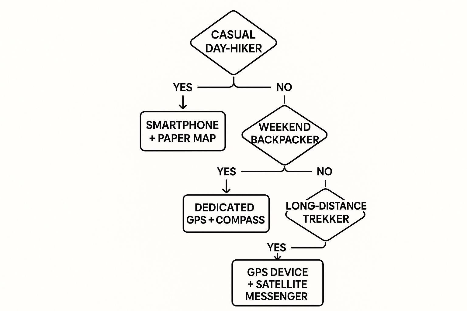
The takeaway is simple: the more remote you go, the more you’ll lean on rugged, purpose-built gear, but the old-school, no-fail backup never loses its importance.
Your navigation toolkit is a direct reflection of your preparedness. By thoughtfully selecting a primary and a backup system based on your hiking style, you’re not just buying gear—you’re investing in your own safety and confidence on the trail.
Your Pre-Hike Navigation Checklist
https://www.youtube.com/embed/HugY6T3Dvho
Real confidence on the trail is built before you even lace up your boots. It’s a quiet assurance that comes from solid preparation and habits that make safety feel like second nature. Think of it like checking the tire pressure before a long road trip—a pre-hike navigation check ensures your entire system is dialed in and ready to go.
This isn’t just about having the right tools, but knowing they'll work when you need them most. The single most important rule here is redundancy. Never, ever bet your safety on a single device. The wilderness is a terrible place to gamble. A good checklist turns these crucial principles into simple, repeatable actions.
Part of that prep work starts at home. Researching your destination is a must. For example, reading through a detailed guide to Big Cottonwood Canyon can give you a heads-up on the terrain, trail conditions, and any specific navigational quirks you might encounter.
Your Essential Pre-Trail System Check
Make these steps an automatic part of your pre-hike routine. It’s a simple process that can be the difference between a minor hiccup and a serious emergency, and it ensures all your navigation tools for hiking are reliable.
-
Charge Everything: This is non-negotiable. Your phone, GPS unit, satellite messenger, and any power banks should be at 100% battery before you leave the house.
-
Download Offline Maps: Don't count on having cell service—you probably won't. Make sure the maps for your entire route are downloaded to your phone and that you can access them in airplane mode.
-
Share Your Plan: Tell a reliable friend or family member exactly where you're going, your planned route, and when you expect to be back. Give them details like your trailhead and a description of your car.
-
Confirm Your Backups: Physically put your hands on your paper map and compass. Make sure they’re actually in your pack. A great little ritual is to take a quick practice bearing in your backyard to keep the skill fresh.
A well-prepared navigation system is as fundamental as sturdy hiking boots or enough water. It’s not an accessory; it's a core piece of your safety equipment that empowers you to explore responsibly and confidently.
This checklist is the final, critical step in getting ready. For a full rundown of everything else you should bring along, take a look at our comprehensive day hike packing list to make sure you’re totally prepared.
A Few Common Questions About Hiking Navigation
As you start piecing together your own navigation system, a few questions always seem to pop up. It's totally normal. Getting these sorted out before you hit the trail is one of the best ways to build real confidence. Let's tackle some of the most frequent ones.
Do I Really Need a Map and Compass If I Have a GPS?
Yes. Full stop.
Think of it this way: your map and compass are like the spare tire in your car. You hope you never have to use it, but you'd be a fool to drive into the backcountry without one. GPS devices and smartphones are amazing, but they rely on batteries that die and electronics that can fail when you least expect it.
A map and compass? They don't need power and are practically indestructible. They're your ultimate foolproof backup, the safety net that guarantees you can find your way home, no matter what happens to your gadgets.
What's the Best Hiking App to Start With?
For anyone just getting their boots dirty, an app like AllTrails is a fantastic starting point. Its biggest win is the massive community-driven library of trails. You get recent reviews, photos, and real-time condition reports from other hikers, which is invaluable. Plus, the interface is super easy to get the hang of.
More advanced hikers often gravitate toward something like Gaia GPS for its powerful mapping layers and customization. But for building skills on well-marked trails, AllTrails gives you everything you need—like offline maps and tracking—without the overwhelming learning curve.
The safest hiker isn't the one with the most expensive gear, but the one with the smartest habits. Answering these questions now helps build the knowledge you need to make good decisions when it matters most.
How Do I Keep My Phone from Dying on a Long Hike?
Ah, the battery life question. This is a critical skill, and luckily, it's pretty simple. There are three big things you need to do:
- Go into Airplane Mode: The second you hit the trail, switch your phone to airplane mode. This stops it from constantly searching for a cell signal, which absolutely torches your battery. Don't worry, the GPS chip in your phone will still work perfectly with your downloaded maps.
- Download Your Maps at Home: Always, always download the maps for your route before you leave home and have a solid Wi-Fi connection. This means your phone doesn't need data on the trail, saving even more juice.
- Carry a Power Bank: This is non-negotiable. A fully charged portable power bank is a lightweight piece of essential safety gear. It can recharge your phone multiple times and is worth every single ounce.
What's the Real Difference Between a GPS Watch and a Handheld GPS?
It really boils down to what you're using it for.
A GPS watch is all about convenience and quick-glance data. It's perfect for trail runners or day-hikers who want to track stats like pace, distance, and elevation right from their wrist without breaking stride.
A handheld GPS, on the other hand, is a dedicated navigation workhorse built for serious, deep-country adventures. You get a much larger screen for better map viewing, way longer battery life (often with swappable AAs), and more powerful satellite reception. Many also come with two-way communication features for emergencies when you're completely off-grid.
At FindTopTrends, we're dedicated to helping you find the essential gear for your next adventure. Explore our curated selection of outdoor and travel essentials to stay prepared on the trail. Discover more at https://findtoptrends.com.
Leave a comment


